|
Gerhard66
|
|
|
Group: Forum Members
Posts: 175,
Visits: 358
|
Dear Markus,
I’m a little bit worried about your statement (... 80 to 90% ...)!
Besides weather briefing and legally irrelevant local specialities, can you please provide just one or two examples, that show clearly SD (with extra paid AIPs included) does not provide sufficient information w.r.t. legally correct flight planning.
Thanks
Gerhard
|
|
|
|
|
Johannes B.
|
|
|
Group: Forum Members
Posts: 53,
Visits: 1
|
+x+xOut of interest, what is your opposition to using the VFR AIP which is the source of that information? It is well integrated into SkyDemon. Someone else pointed out that the combined cost of SkyDemon and the VFR AIP is less than the Jeppesen product used to cost. Dear Tim Dawson, it is a widespread misbelief that looking at a Skydemon graphical map representation of "the world, the airspaces and everything" is sufficient as replacement for a proper flight preparation. We don't have to start an academic discussion on the stupidity of such misconception. I agree Skydemon has come to a real nice maturity as navigational aid including the VFR AIP, but everybody has to repeat over and over agin - it is only a 80 to 90 percent aid, no replacement. Best Markus Which missing 10 to 20% are you referring to? Surely it is partially necessary to check alternate sources of information such as the weather or airfield websites for local specialties as for example noise abaitment procedures due to critical residents. But these are aspects I do not require or demand from a navigation software such as SkyDemon.
|
|
|
|
|
pilot-byom
|
|
|
Group: Forum Members
Posts: 323,
Visits: 388
|
+xOut of interest, what is your opposition to using the VFR AIP which is the source of that information? It is well integrated into SkyDemon. Someone else pointed out that the combined cost of SkyDemon and the VFR AIP is less than the Jeppesen product used to cost. Dear Tim Dawson, it is a widespread misbelief that looking at a Skydemon graphical map representation of "the world, the airspaces and everything" is sufficient as replacement for a proper flight preparation. We don't have to start an academic discussion on the stupidity of such misconception. I agree Skydemon has come to a real nice maturity as navigational aid including the VFR AIP, but everybody has to repeat over and over agin - it is only a 80 to 90 percent aid, no replacement. Best Markus
|
|
|
|
|
Tim Dawson
|
|
|
Group: Forum Members
Posts: 8.3K,
Visits: 10K
|
Out of interest, what is your opposition to using the VFR AIP which is the source of that information? It is well integrated into SkyDemon. Someone else pointed out that the combined cost of SkyDemon and the VFR AIP is less than the Jeppesen product used to cost.
|
|
|
|
|
screen
|
|
|
Group: Forum Members
Posts: 20,
Visits: 72
|
+xscreen - yes, again you were told this on page 1 of this thread.
There is occasionally textual information about approaches, departures or other conditions in the VFR AIP approach plates.
We understand you would like us to duplicate all possible information found on that official source into our own data. I do not believe any product does that, but we will bear in mind your request for levels for approach and departure lanes in the future. Thanks for the answer, Jeppesen MFD VFR had entered all information directly into the card. A lot of former users of MFD miss this detail in the other programs offered (SD, foreflight, Garmin, etc.)
|
|
|
|
|
Tim Dawson
|
|
|
Group: Forum Members
Posts: 8.3K,
Visits: 10K
|
screen - yes, again you were told this on page 1 of this thread.
There is occasionally textual information about approaches, departures or other conditions in the VFR AIP approach plates.
We understand you would like us to duplicate all possible information found on that official source into our own data. I do not believe any product does that, but we will bear in mind your request for levels for approach and departure lanes in the future.
|
|
|
|
|
lhe
|
|
|
Group: Forum Members
Posts: 154,
Visits: 445
|
It is clear from the German VFR AIP that there is maximum altitude of 3000' for VFR APCH/DEP. Whether this information is associated with the routes or the VRPs seems like a minor point. The important thing is that the information is given somewhere.
|
|
|
|
|
screen
|
|
|
Group: Forum Members
Posts: 20,
Visits: 72
|
+xYes - they use exactly the same data as the Jeppesen product.
I will again ask you to refer to the official source of this, which is the DFS VFR AIP. Somebody helpfully posted a screenshot of it on page 1. After consultation with the EDNY air traffic control center, they informed by email that this was a requirement of air traffic control. The heights can be found on the AIP VFR map (Appendix). The prescribed heights would be found above the word BODENSEE on the map.
Original Text in Deutsch:
|
|
|
|
|
Tim Dawson
|
|
|
Group: Forum Members
Posts: 8.3K,
Visits: 10K
|
Yes - they use exactly the same data as the Jeppesen product.
I will again ask you to refer to the official source of this, which is the DFS VFR AIP. Somebody helpfully posted a screenshot of it on page 1.
|
|
|
|
|
screen
|
|
|
Group: Forum Members
Posts: 20,
Visits: 72
|
this is a current screenshot of foreflight, are they wrong in this case? 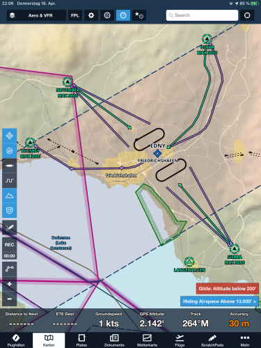
|
|
|
|