By Gerhard66 - 4/14/2020 8:03:24 PM
Your screenshots look like scanned, used paper charts.
Maybe, they’re outdated?
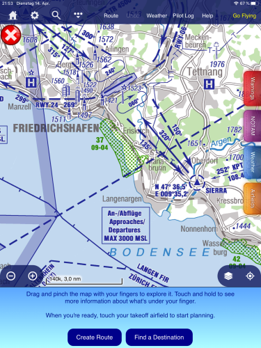
The latest official DFS chart indicates a maximum altitude of 3000 ft for approaches and departures.
|
By screen - 4/15/2020 11:39:44 AM
+xYour screenshots look like scanned, used paper charts. Maybe, they’re outdated? The latest official DFS chart indicates a maximum altitude of 3000 ft for approaches and departures. Yes, it is a screenshot of a printout of the approach chart. The card is from Dec 2019.I am sure that if Skydemon would directly integrate the maps like Jeppesen MFD (approach maps and detailed airport maps), more pilots would buy SD !! |
By grahamb - 4/15/2020 1:42:48 PM
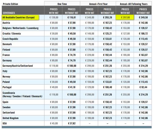
What was the price of an annual subscription to MFD, including all the VFR info and plates, compared with SD and the German VFR add-on?
|
By screen - 4/15/2020 3:13:50 PM
+xWhat was the price of an annual subscription to MFD, including all the VFR info and plates, compared with SD and the German VFR add-on? All of Europe cost € 297 .-- including 3 days weather forecast, GAFOR and wind etc.
|
By grahamb - 4/15/2020 6:08:25 PM
+x+x[quote]What was the price of an annual subscription to MFD, including all the VFR info and plates, compared with SD and the German VFR add-on? All of Europe cost € 297 .-- including 3 days weather forecast, GAFOR and wind etc.
If the altitude data you need is shown on the airfield plates and area charts that come in the DFS VFR add-in, then you've just saved over a €100 per year. You can get weather from lots of places these days.
|
By screen - 4/15/2020 7:23:27 PM
+x+x+x[quote]What was the price of an annual subscription to MFD, including all the VFR info and plates, compared with SD and the German VFR add-on? All of Europe cost € 297 .-- including 3 days weather forecast, GAFOR and wind etc.
If the altitude data you need is shown on the airfield plates and area charts that come in the DFS VFR add-in, then you've just saved over a €100 per year. You can get weather from lots of places these days.
Thank you for the bill :-)But I fly not only in Germany, but also in Italy, Switzerland, Austria and sometimes in the Czech Republic. now calculate what all this costs?At the same time, as accurately and understandably as the weather or the wind was shown in all altitudes (that for 3 days in advance), I only know from jeppesen mfd VFR |
By Tim Dawson - 4/16/2020 9:42:31 AM
screen, I asked you what made you think the reporting points had a specified level associated with them. Thank you for confirming your expectation was set by another product. That data is incorrect; the reporting points do not have specific levels associated with them.
There is a general note associated with EDNY on the DFS approach chart that approaches/departures are to be conducted at 3000' max. That isn't the same as reporting points having a specific level associated with them.
As others have pointed out, the product you mentioned was a lot more expensive than SkyDemon. All the information you need is in SkyDemon with the DFS VFR AIP. Unlike all other countries, this AIP is a paid add-on because Germany will not release it for free.
|
By screen - 4/16/2020 9:16:41 PM
this is a current screenshot of foreflight, are they wrong in this case?
|
By Tim Dawson - 4/20/2020 8:56:54 AM
Yes - they use exactly the same data as the Jeppesen product.
I will again ask you to refer to the official source of this, which is the DFS VFR AIP. Somebody helpfully posted a screenshot of it on page 1.
|
By screen - 4/20/2020 1:11:44 PM
+xYes - they use exactly the same data as the Jeppesen product.
I will again ask you to refer to the official source of this, which is the DFS VFR AIP. Somebody helpfully posted a screenshot of it on page 1. After consultation with the EDNY air traffic control center, they informed by email that this was a requirement of air traffic control. The heights can be found on the AIP VFR map (Appendix). The prescribed heights would be found above the word BODENSEE on the map.
Original Text in Deutsch:
|
By lhe - 4/21/2020 5:19:08 PM
It is clear from the German VFR AIP that there is maximum altitude of 3000' for VFR APCH/DEP. Whether this information is associated with the routes or the VRPs seems like a minor point. The important thing is that the information is given somewhere.
|
By Tim Dawson - 4/22/2020 8:33:07 AM
screen - yes, again you were told this on page 1 of this thread.
There is occasionally textual information about approaches, departures or other conditions in the VFR AIP approach plates.
We understand you would like us to duplicate all possible information found on that official source into our own data. I do not believe any product does that, but we will bear in mind your request for levels for approach and departure lanes in the future.
|
By screen - 4/23/2020 6:27:51 PM
+xscreen - yes, again you were told this on page 1 of this thread.
There is occasionally textual information about approaches, departures or other conditions in the VFR AIP approach plates.
We understand you would like us to duplicate all possible information found on that official source into our own data. I do not believe any product does that, but we will bear in mind your request for levels for approach and departure lanes in the future. Thanks for the answer, Jeppesen MFD VFR had entered all information directly into the card. A lot of former users of MFD miss this detail in the other programs offered (SD, foreflight, Garmin, etc.) |
By Tim Dawson - 4/27/2020 8:58:05 AM
Out of interest, what is your opposition to using the VFR AIP which is the source of that information? It is well integrated into SkyDemon. Someone else pointed out that the combined cost of SkyDemon and the VFR AIP is less than the Jeppesen product used to cost.
|
By pilot-byom - 4/27/2020 9:29:53 AM
+xOut of interest, what is your opposition to using the VFR AIP which is the source of that information? It is well integrated into SkyDemon. Someone else pointed out that the combined cost of SkyDemon and the VFR AIP is less than the Jeppesen product used to cost.
Dear Tim Dawson,it is a widespread misbelief that looking at a Skydemon graphical map representation of "the world, the airspaces and everything" is sufficient as replacement for a proper flight preparation. We don't have to start an academic discussion on the stupidity of such misconception. I agree Skydemon has come to a real nice maturity as navigational aid including the VFR AIP, but everybody has to repeat over and over agin - it is only a 80 to 90 percent aid, no replacement. Best Markus
|
By Johannes B. - 5/2/2020 8:50:00 AM
+x+xOut of interest, what is your opposition to using the VFR AIP which is the source of that information? It is well integrated into SkyDemon. Someone else pointed out that the combined cost of SkyDemon and the VFR AIP is less than the Jeppesen product used to cost. Dear Tim Dawson, it is a widespread misbelief that looking at a Skydemon graphical map representation of "the world, the airspaces and everything" is sufficient as replacement for a proper flight preparation. We don't have to start an academic discussion on the stupidity of such misconception. I agree Skydemon has come to a real nice maturity as navigational aid including the VFR AIP, but everybody has to repeat over and over agin - it is only a 80 to 90 percent aid, no replacement. Best Markus Which missing 10 to 20% are you referring to? Surely it is partially necessary to check alternate sources of information such as the weather or airfield websites for local specialties as for example noise abaitment procedures due to critical residents. But these are aspects I do not require or demand from a navigation software such as SkyDemon. |
By Gerhard66 - 5/2/2020 9:26:50 AM
Dear Markus,
I’m a little bit worried about your statement (... 80 to 90% ...)!
Besides weather briefing and legally irrelevant local specialities, can you please provide just one or two examples, that show clearly SD (with extra paid AIPs included) does not provide sufficient information w.r.t. legally correct flight planning.
Thanks
Gerhard
|
By screen - 4/10/2020 11:08:25 AM
Hello dear forum,
I've been flying with Skydemon for a while now, because Jeppesen MFD VFR has been taken off the market.
Unfortunately, I personally miss some important things. For example, at Friedrichshafen Airport (EDNY) there is no height information for the mandatory reporting points. Furthermore, the waiting round (holding pattern) is missing.
The parking lot for general aviation was also located at MFD VFR etc.
Due to the lack of such important features, the program is unfortunately not yet perfect. If Skydemon displayed the rounds etc. as in MFD VFR, many pilots would switch to this product.
LG from Austria
|