|
s1l3ntgl1d3r
|
|
|
Group: Forum Members
Posts: 7,
Visits: 0
|
Hi I am in the process of getting my PPL in Switzerland. After about 20hrs I did my second navigation flight last friday. I really like to learn to navigate only with the ICAO map at first, but I tried Skydemon the other day and I must say it is really great as a planing tool. Here in Switzerland the airspace is really tight and we have lots of TMAs and almost during every flight we need a clearance to fly through them. To ask for the clearance it is really important to know the position of the aircraft, and due to the fact that the airspace is so small, the position of the aircraft has to be precise, my biggest problem with SD is that lots of names of "big" towns are missing, which in fact makes SD not usable for me at the moment. I have read that lots of Swiss pilots have the same issue but I don't want to give up SD as it looks to be a promissing APP. Is there a way to add the names that can be found on the ICAO map? Thank you for your help. Regards, Max Here an example of what I mean: ICAO Map: 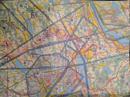 SD view: ( I have highlighted some of the cities for which SD doesnt show a name.) 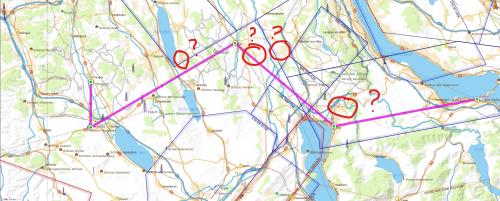 Here a more detailed shot of the ICAO Map: 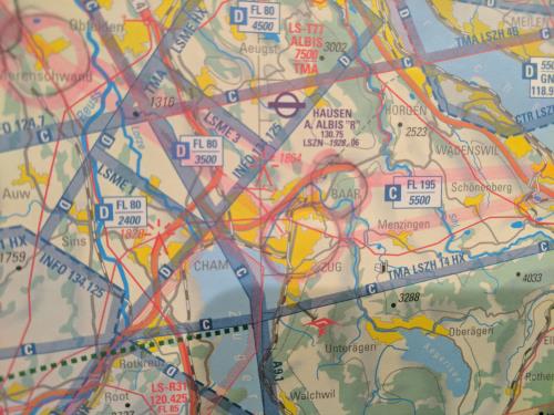
|
|
|
|
|
Tony N
|
|
|
Group: Forum Members
Posts: 384,
Visits: 2.6K
|
There was a discussion a few months ago about a similar issue for pilots in the UK. SD was displaying "current aircraft position" relative to the names of small towns and locations which weren't recognized by ATC units. Tim changed the algorithm to display "current" position info relative to larger towns and VRPs etc.
Perhaps a similar issue for Swiss pilots?
Or perhaps an issue with the map data for Switzerland?
Tony
|
|
|
|
|
s1l3ntgl1d3r
|
|
|
Group: Forum Members
Posts: 7,
Visits: 0
|
HI I think I was not precise enough in my question. The issue is that names of relatevely big towns are missing on the SD chart that are present on the ICAO map. Switzerland is so small and we need the names of the smaller towns to give the controller a precise location. I mean in the end its just a request to the developers of SD to have the same names as the ICAO Chart, then they would sell much more SD here in Switzerland as they are really precise and prefer other products due to this issue. Here another printscreen from SD. The towns in green are labeled in SD with their name, but the one next to it are not. For example the town ZUG is visible on SD but the neighbour town BAAR is not labeled in SD. 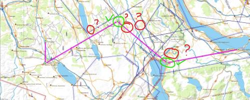 Here the same detailed view of the ICAO Map as you can see the two towns which i took in this example are marked and recognizable. 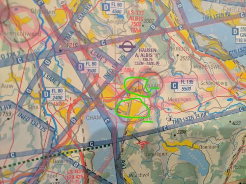 Hope this helped to make my question a little preciser. Regards, Max
|
|
|
|
|
Tim Dawson
|
|
|
Group: Forum Members
Posts: 8.3K,
Visits: 10K
|
I have attached a screenshot of SkyDemon in that region at 250k scale. I think we label plenty of towns. Are you navigating at an even larger map scale than this? Your screenshot looks almost like it's at 100k; perhaps you're flying a helicopter? I'm afraid we are not in the business of simply copying other charts. The cartographers who created the 500k Switzerland chart you are comparing with have made their own decisions about which towns to name at their fixed scale; SkyDemon supports many different scales but we cannot include small villages or even larger towns when they're right next to other (even larger) towns whose labels have already been included. We did review this in September last year and were able to include many more towns in Switzerland by switching data provider. At the moment when I look at the map at 250k zoom scale, like the screenshot I am attaching, I can see that there isn't really enough room for more town labels. 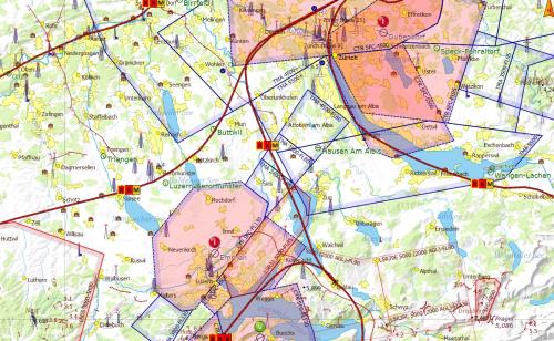
|
|
|
|
|
s1l3ntgl1d3r
|
|
|
Group: Forum Members
Posts: 7,
Visits: 0
|
+xI have attached a screenshot of SkyDemon in that region at 250k scale. I think we label plenty of towns. Are you navigating at an even larger map scale than this? Your screenshot looks almost like it's at 100k; perhaps you're flying a helicopter? I'm afraid we are not in the business of simply copying other charts. The cartographers who created the 500k Switzerland chart you are comparing with have made their own decisions about which towns to name at their fixed scale; SkyDemon supports many different scales but we cannot include small villages or even larger towns when they're right next to other (even larger) towns whose labels have already been included. We did review this in September last year and were able to include many more towns in Switzerland by switching data provider. At the moment when I look at the map at 250k zoom scale, like the screenshot I am attaching, I can see that there isn't really enough room for more town labels. Hi Tim Thank you really much that you took the time to answer my question. I really like SD and I will keep my subscription for the moment. You asked what kind of Chart I am using vor VFR navigation? It is the Zürich Area Chart ICAO - 1:250000 (GND until FL 195). It would be great if the map would adapt to the "zoom level" and show the same names as this chart. This "issue" is known under VFR Pilots and is holding back a lot of customers to use SD here in Switzerland. Thank you anyways for your kind support in this matter! Regards Max
|
|
|
|
|
Tim Dawson
|
|
|
Group: Forum Members
Posts: 8.3K,
Visits: 10K
|
We do adapt to the zoom level, but the town selection is an algorithm based upon population of the town; we cannot simply copy what another cartographer has done on an existing product. The problem is not simply one of copyright: if ATC want pilots to report at a specific place, that place should really be an officially published VRP or at least mentioned in the AIP.
Having said all that, we do have plans to enable more smaller towns to appear in our maps at high zoom levels, but we are not there yet. Hopefully later this year.
|
|
|
|
|
s1l3ntgl1d3r
|
|
|
Group: Forum Members
Posts: 7,
Visits: 0
|
Hi Tim
I am really impressed by how much effort you put in satisfying every customer that is interested in SD. I really like your product, I now use it to plan my flights and as a backup I use an ICAO map. The "issue" I have with the map, is a minor thing but it gets in the way of reccomending your product to all my swiss collegues.
I hope you can find a solution for your maps, as the rest of the appl is really cool.
Regards
Max
|
|
|
|
|
Vladimir Vician
|
|
|
Group: Forum Members
Posts: 1,
Visits: 0
|
+xWe do adapt to the zoom level, but the town selection is an algorithm based upon population of the town; we cannot simply copy what another cartographer has done on an existing product. The problem is not simply one of copyright: if ATC want pilots to report at a specific place, that place should really be an officially published VRP or at least mentioned in the AIP. Having said all that, we do have plans to enable more smaller towns to appear in our maps at high zoom levels, but we are not there yet. Hopefully later this year. Hope this is on the priority list. Because, i need to use another product to be able to report my position !!!. Anyways SD is great product. And I like it. This is last think... More cities names on zoomed map, or be able to custom set density of cities names or higher density along planed route. Hope you plan to incerase density globaly, as I flying in slovakia.
|
|
|
|
|
Tim Dawson
|
|
|
Group: Forum Members
Posts: 8.3K,
Visits: 10K
|
Please feel free to tell us exactly where you were, and how the position offered by SkyDemon was insufficient.
|
|
|
|
|
Chris_LSZO
|
|
|
Group: Forum Members
Posts: 107,
Visits: 149
|
Often in Switzerland a controller say to me: report village xyz. This mean a village shown at the ICAO map. Its not nice to me, if I can't see this village in Skydemon...
Because this, for me its very important to have the same villages in Skydemon like on the ICAO chart.
Chris
|
|
|
|