|
cocoroman
|
|
|
Group: Forum Members
Posts: 70,
Visits: 116
|
O.K. Guys, I have checked on my Android: Nexus 10, Samsung S6 Edge and on my PC that; So we don't have any information of FIR Boundry for in Switzerland (Not talking about country bounderies). Obviously I have not checked the other countries, but at least, if I'm not mistaken, we do not have any of FIR separation like Geneve and Zurich etc. Normally Pilot's should definitely know, when the are leaving or entering the FIR Boundries. Please , can you check this again. Thanks a lot..
|
|
|
|
|
Tim Dawson
|
|
|
Group: Forum Members
Posts: 8.3K,
Visits: 10K
|
FIR boundaries are shown clearly on SkyDemon maps, assuming you haven't turned them off. Check your Map Layers.
|
|
|
|
|
cocoroman
|
|
|
Group: Forum Members
Posts: 70,
Visits: 116
|
+xFIR boundaries are shown clearly on SkyDemon maps, assuming you haven't turned them off. Check your Map Layers. Hi Tim, sure I have turned them on. Still, it does not show any separation of FIR Boundries for Switzerland. We Have main of two FIR Boundries in Switzerland. Which is Swiss French(Geneva) and Swiss German(Zurich), actually Swiss Italian part belongs to Swiss German FIR. I have tried again in all my setup's; PC, Nexus 10 and Samsung S6 Edge. It is not shown at all, there for I have turned on FIR's many times on, but no go. Everytime I turn FIR on SD, it will only show me borders between France, Italy and Germany etc.. I must stress there is no separation in Swiss FIR's . Cheers,
|
|
|
|
|
efrenken
|
|
|
Group: Forum Members
Posts: 265,
Visits: 3.5K
|
cocoroman is right, I've installed the Switzerland chart and it doesn't show the boundary between the 2 FIRs, while the German FIR boundaries are shown.
Eric
|
|
|
|
|
Serge
|
|
|
Group: Forum Members
Posts: 35,
Visits: 265
|
attached the visual that it is missing 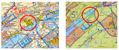 source is the swiss ICAO map
|
|
|
|
|
Tim Dawson
|
|
|
Group: Forum Members
Posts: 8.3K,
Visits: 10K
|
Guys, Switzerland has only one FIR. Check AIP Switzerland ENR 2.1.
Are you talking about the delineation between the two FIS services in Switzerland?
|
|
|
|
|
Serge
|
|
|
Group: Forum Members
Posts: 35,
Visits: 265
|
Yes Tim you are right we have two FIS and not two FIR sorry didn't checked it, to much acronyms :-), but nevertheless could this be integrated?
|
|
|
|
|
cocoroman
|
|
|
Group: Forum Members
Posts: 70,
Visits: 116
|
+xGuys, Switzerland has only one FIR. Check AIP Switzerland ENR 2.1. Are you talking about the delineation between the two FIS services in Switzerland? As well you say, between (TWO) FIR services sure yes.. And it is not shown on the Map. Final statement; Obviously we're real world Pilot's thinking we can manage whole think with SD, no we can't.. From now on, I'll be more careful with SD. Actually I'm flying tomorrow to LSGY from LSGN, and after to LSGL and back to LSGN. I'll take my paper Map with me. otherwise I don't even know where are the separations are After SD map. I won't even know where is the separation on my Android map, because there is none ..
|
|
|
|
|
Tim Dawson
|
|
|
Group: Forum Members
Posts: 8.3K,
Visits: 10K
|
SkyDemon has never shown the boundaries between FIS sectors on the map - there is no need for such a display on a dynamic chart.
We do show the boundaries in Virtual Radar, where we even show you the upcoming frequency to change to as well. Also, you can long-press on the main map to see the FIS frequency at any area, and when you look at it, its border is shown temporarily.
|
|
|
|
|
alexis.hellen@gmail.com
|
|
|
Group: Forum Members
Posts: 56,
Visits: 753
|
+x+xGuys, Switzerland has only one FIR. Check AIP Switzerland ENR 2.1. Are you talking about the delineation between the two FIS services in Switzerland? As well you say, between (TWO) FIR services sure yes.. And it is not shown on the Map. Final statement; Obviously we're real world Pilot's thinking we can manage whole think with SD, no we can't.. From now on, I'll be more careful with SD. Actually I'm flying tomorrow to LSGY from LSGN, and after to LSGL and back to LSGN. I'll take my paper Map with me. otherwise I don't even know where are the separations are After SD map. I won't even know where is the separation on my Android map, because there is none .. Here's an illustration of what Tim says about seeing FIS in virtual radar, and ok no the chart when drifting by "what'shere". According to me, the flight you are describing (LSGN-LSGY-LSGL-LSGN) all taked place in the Geneva FIS area. I personally always have my oaci paper chart available. I could imagine that having the possibility, in "layers", to choose to show our not the FIS areas could be an elegant solution. Cheers, Alexis
|
|
|
|