|
gb-rk
|
|
|
Group: Forum Members
Posts: 9,
Visits: 48
|
Hi, what is the reason that the charts, at least from Germany, are so inaccurate? Two examples: Ammersee: Why is the bird area as well as the control zone shifted by one or two kilometers to West? 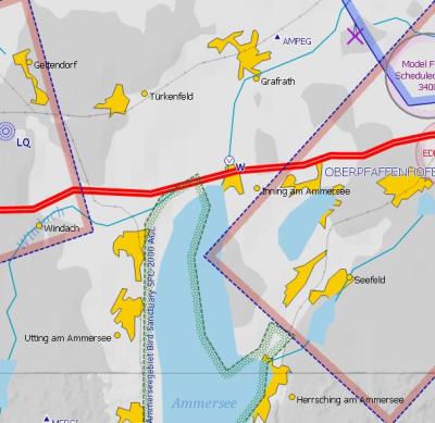 Peissenberg: In the chart, the Ammer rivers flows through the village Peissenberg. This is definitely wrong! It flows about four kilometers east of Peissenberg. 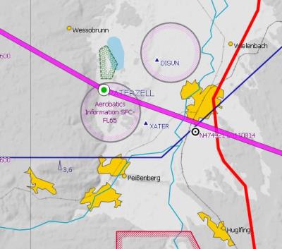 What is the reason for these inaccurate charts? Is there an improvement to expect. it concerns all available chart styles. This poor chart quality is not really a help for VFR flights. Is the any improvement to expect? Gerhard
|
|
|
|
|
ckurz7000
|
|
|
Group: Forum Members
Posts: 538,
Visits: 2.2K
|
Hallo Gerhard,
yes, this is a known issue. Personally, I would like better chart accuracy, too. Particularly, since people navigating by VFR rely on such things as a river flowing through a town or a street passing a certain way. Therefore I, too, cast my vote for better chart accuracy where it matters.
-- Chris.
|
|
|
|
|
Tim Dawson
|
|
|
Group: Forum Members
Posts: 8.3K,
Visits: 10K
|
I have asked the providers of our background scenery data (roads, railways, lakes and rivers) if they can make it more accurate in this area. We do not create this mapping data ourselves (unlike all the aeronautical data) so there are times like this where the limits on its precision show themselves quite starkly when compared to our aeronautical data, which is precise.
|
|
|
|
|
Anton Lechner
|
|
|
Group: Forum Members
Posts: 1,
Visits: 8
|
But boarders of Control Zones are aeronautical datas, are't they? See the Upper picture.
|
|
|
|
|
efrenken
|
|
|
Group: Forum Members
Posts: 265,
Visits: 3.5K
|
It could be that the surface of the earth has been shifted 2 km to the west which would accurate aeronautical data make appear as if it had been shifted 2 km to the east. Just a thought.
Eric
|
|
|
|
|
ckurz7000
|
|
|
Group: Forum Members
Posts: 538,
Visits: 2.2K
|
I am, indeed, surprised that an inaccuracy of surface features of the order of 2 km is deemed acceptable for an otherwise great piece of software. If SD is actually paying someone to provide these data, I would seriously consider switching the provider.
And this in days where accurate terrain and cultural data is available FOR FREE just to download. I am, of course, talking about Open Street Map. The data comes vectorized in databank format. If that doesn't suit you, there are a zillion utility programs out there to modify and massage the data until you like it. What gives???
-- Chris.
|
|
|
|
|
Tim Dawson
|
|
|
Group: Forum Members
Posts: 8.3K,
Visits: 10K
|
The borders of the control zones are perfect. It is, as somebody else suggested, the lake itself which is slightly offset.
We do indeed license this geographical data and the vendor has said they will correct the offsetting in this area in a forthcoming update.
There are a variety of reasons why OpenStreetMap data is not deemed suitable for our purposes; dozens of man-hours have been devoted to analysing the various sources of vectorised scenery data over the years.
|
|
|
|
|
ckurz7000
|
|
|
Group: Forum Members
Posts: 538,
Visits: 2.2K
|
I hear what you are saying, Tim. Still as far as I know SD is the only aviation software knowingly accepting such inaccuracies in its basemap. It is the biggest downside to the program. In regions such as the above you can, reall, only rely on airspace avoidance and not vfr navigation by matching map features to the landscape outside. If I were responsible for SD, this is a stigma I would work really hard to lose quickly.
-- Chris.
|
|
|
|
|
Tim Dawson
|
|
|
Group: Forum Members
Posts: 8.3K,
Visits: 10K
|
Other vendors tend to use other people's raster basemaps, rather than rendering their own with vectors. Doing the latter is of huge benefit to us, but it makes our job harder. There aren't as many sources of vector basemap data in the world as you might imagine. Perhaps it's time for us to look again at OSM data but we've always found it terribly flawed in the past.
|
|
|
|
|
ckurz7000
|
|
|
Group: Forum Members
Posts: 538,
Visits: 2.2K
|
Tim, I would definitely take a hard look at OSM data again. It is being used far and wide and has gotten a lot more reliable. To be frank, I think it would be a significant improvement over what you're using now.
Greetings, -- Chris.
|
|
|
|