Important: These forums are for discussions between SkyDemon users. They are not routinely monitored by SkyDemon staff so any urgent issues should be sent directly to our Customer Support.

SD collaborative grouth


Author
Message
Isaache
Isaache
Too Much Forum (1.4K reputation)Too Much Forum (1.4K reputation)Too Much Forum (1.4K reputation)Too Much Forum (1.4K reputation)Too Much Forum (1.4K reputation)Too Much Forum (1.4K reputation)Too Much Forum (1.4K reputation)Too Much Forum (1.4K reputation)Too Much Forum (1.4K reputation)
Group: Forum Members
Posts: 10, Visits: 27
Hi,

I have been seeing many posts in this form where people asks the data of a particular location to be amended in one way or another just to be told that you only trust the official/original source of information. For an application designed to be used in VFR this is, in my opinion, not an optimal posture.

Let me explain why I think in this way. For what I have seen you use (as most of the applications that I have seen) the Airport Reference Point as the coordinates of the airport which are used to put the center of the airport icon on the vectorial map when the ARP was never intended to be used for that purpose, now let's take a look at an example, LESU (La Seu d'Urgell airport), this airport ARP is located at the very end of the runway (opposite of the apron and hangars), this means that in an emergency situation with low visibility it is going to be harder to spot something on the ground if the pilot executes a "Direct to".

A similar thing can be said of some charts that I have seen that are outdated or providing very optimistic runway runs, as of today the best source of information are the current ortophotos of the local cartographic institutions which normally provide enough resolution to measure runway, lengths, widths, headers, and in some cases where precise DTMs exist derive accurate ortometric heights.

Further more, given the fact that SD provide the wonderful pseudo ILS, are you sure you want to use as runway header coordinates the published headers or the intersection between the runway center line and the PAPI lights? In most cases (if not all) the pseudo ILS would point the pilot short of the runway if the officially published coordinates are used...

Obviously I'm not expecting SD developers to manually review every airport however I do seem to remember a post or maybe a new where some developer (Tim?) said that SD was going to support community made inputs to update the aeronautical database, is this going to happen any time soon?

I linked a file below my lines, is there any chance that some of it is taken in to consideration (the names of the airfields have the "isa" prefix so that I can easily differentiate from the stock airports) 

Regardless of my comments I do believe this app is a great tool.

Thanks

Isaac
Attachments
CatalunyaSmall.airfields.xml (571 views, 45.00 KB)
Tim Dawson
Tim Dawson
SkyDemon Team (665K reputation)SkyDemon Team (665K reputation)SkyDemon Team (665K reputation)SkyDemon Team (665K reputation)SkyDemon Team (665K reputation)SkyDemon Team (665K reputation)SkyDemon Team (665K reputation)SkyDemon Team (665K reputation)SkyDemon Team (665K reputation)
Group: Forum Members
Posts: 8K, Visits: 9.1K
You can share custom-made airfield data with friends, that's why we made the feature available. For data integrity reasons, though, we couldn't accept data from third-parties for inclusion in the standard SkyDemon charts upon which tens of thousands of pilots rely. I would point out that satellite photography is not a good source of runway data as it's often out of date.
Isaache
Isaache
Too Much Forum (1.4K reputation)Too Much Forum (1.4K reputation)Too Much Forum (1.4K reputation)Too Much Forum (1.4K reputation)Too Much Forum (1.4K reputation)Too Much Forum (1.4K reputation)Too Much Forum (1.4K reputation)Too Much Forum (1.4K reputation)Too Much Forum (1.4K reputation)
Group: Forum Members
Posts: 10, Visits: 27
Hi Tim,

I certainly agree with you, Google Earth/maps and similar services from Microsoft and the like are showing, in some instances, outdated imagery, specially from places that are visited less frequently, this is why I mentioned the official cartographic institutions of the European countries. Most institutions consider the ortophoto the product to promote when there is a need for current cartographic data.

Why is this affecting SD, because I know for a act that it would be prohibitive for SD developers to cross check every airfield against proper cartographic data however we, the community, can do this job for you, let's put some example:
http://forums.skydemon.aero/uploads/images/a2e57a8e-0b84-4a8b-91ca-da57.png

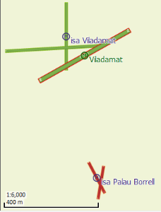
SD is showing Viladamat airfield (Spain) with the old runway configuration and is not showing another airfield located 500 metres south.

http://forums.skydemon.aero/uploads/images/11d4935a-f79f-45bd-835e-81ab.png

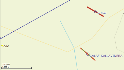
Now let's take a look Calaf airfield, the SD representation is about 1Km south where it should be ("isa Calaf" is correct).

And this can be made extensive to other airfields in my file.

I know I'm being a pain with the positional accuracy and all that stuff but being a land surveyor myself I have hard time trying to keep my mouth shut. Sorry about that.

Thanks for taking the time.

PS1: I believe it would be helpful to include some sort of "exclusion zone" in the DataCreator.exe so that we can hide stock data selectively.

Isaac
Edited 1/12/2015 4:40:47 PM by Isaache
Tim Dawson
Tim Dawson
SkyDemon Team (665K reputation)SkyDemon Team (665K reputation)SkyDemon Team (665K reputation)SkyDemon Team (665K reputation)SkyDemon Team (665K reputation)SkyDemon Team (665K reputation)SkyDemon Team (665K reputation)SkyDemon Team (665K reputation)SkyDemon Team (665K reputation)
Group: Forum Members
Posts: 8K, Visits: 9.1K
We can't take community-sourced data because it's too much of a liability; there is no way of us cross-checking the data. Perhaps you could get in touch by email if you'd be interested in some sort of deal where we could reimburse you for such contributions, since it's your field of expertise?
Edited 1/13/2015 12:38:37 PM by Tim Dawson
Isaache
Isaache
Too Much Forum (1.4K reputation)Too Much Forum (1.4K reputation)Too Much Forum (1.4K reputation)Too Much Forum (1.4K reputation)Too Much Forum (1.4K reputation)Too Much Forum (1.4K reputation)Too Much Forum (1.4K reputation)Too Much Forum (1.4K reputation)Too Much Forum (1.4K reputation)
Group: Forum Members
Posts: 10, Visits: 27
Hi Tim,

I tried to send you an email but for some reason I can't use the forum to send you an email, it says something like the admin has disabled that feature in my account...

Isaac
GO

Merge Selected

Merge into selected topic...


Merge into merge target...


Merge into a specific topic ID...


Reading This Topic

Login

Explore
Messages
Mentions
Search