|
MikeTwoOne
|
|
|
Group: Forum Members
Posts: 147,
Visits: 2.1K
|
I tried it this morning and this is a great addition to the map.
Thanks!
M
|
|
|
|
|
Gyro79
|
|
|
Group: Forum Members
Posts: 20,
Visits: 494
|
+xWe have added these to our France chart with effect from the next AIRAC update. Initially with a diameter of 1nm, we will see how we get on. Great feature ! 1 nm is small enough not to clutter the map and big enough to bring one's attention to it as well as precise its center coordinates. Well done. José
|
|
|
|
|
Tim Dawson
|
|
|
Group: Forum Members
Posts: 8.2K,
Visits: 9.6K
|
We have added these to our France chart with effect from the next AIRAC update. Initially with a diameter of 1nm, we will see how we get on.
|
|
|
|
|
MikeTwoOne
|
|
|
Group: Forum Members
Posts: 147,
Visits: 2.1K
|
I had a look at last year articles in the French papers, and it appears that some pilots have been in trouble after flying over such sites. One helicopter pilot have been sued, has lost his job and has spent a lot of money (3 years judiciary process) to prove he was not guilty (and not recover his job, of course). In his case, the site was a prison (every prison is such a special zone - so special that the sign itself is painted on the roof, see attached file and/or check with google earth!). 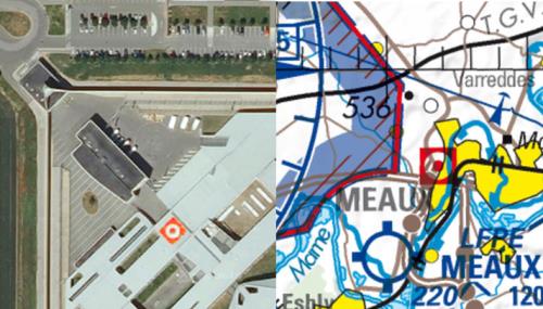 So, the unknown radius is of course an issue but applying the same mecanism to those areas than the one SD uses for windmills/antennas/chimneys/... would certainly be a good solution because in 2016, french authorities won't be forgiving with pilots flying over an explosive factory... M
|
|
|
|
|
Tim Dawson
|
|
|
Group: Forum Members
Posts: 8.2K,
Visits: 9.6K
|
We could show them with some sort of nominal radius, but then we're making stuff up. I've never been very comfortable making stuff up in our data.
If one were to fly over these buildings, how could you possibly get into trouble, given that nowhere does it say how close you're allowed to be before the altitude restriction is effective?
|
|
|
|
|
Tony N
|
|
|
Group: Forum Members
Posts: 365,
Visits: 2.6K
|
+xWow, three years ago and still the same? Shifu, Yes, I am aware of the overflight restrictions over French towns and settlements so that is why I plan on paper and then plot route on SD. It was the red square "points of interest" that I was concerned about as very easy to miss and not identified in SD. Tony
|
|
|
|
|
MikeTwoOne
|
|
|
Group: Forum Members
Posts: 147,
Visits: 2.1K
|
Hi, For reference, it has been discussed in this topic too : http://forums.skydemon.aero/Topic10803.aspx  M
|
|
|
|
|
Tony N
|
|
|
Group: Forum Members
Posts: 365,
Visits: 2.6K
|
I suppose you could assign a nominal 1 NM radius and 1000 AGL height restriction around these locations?
Strangely, as mentioned previously, on the Belgian 1:500,000 they actually mark them as restricted airspace with a 1 NM radius hatched area.
The legend on the Belgian map for the example quoted above is "LF-P PITGAM / GND-3300 AGL".
The only reason I mentioned this is that, for those who may never buy a paper map and rely solely on SD, they would never know of the existence of these "restricted" locations. That is what caught my attention while doing some flight planning on a paper map and looking at SD.
Tony
|
|
|
|
|
Tim Dawson
|
|
|
Group: Forum Members
Posts: 8.2K,
Visits: 9.6K
|
As I recall, it's because we don't have an appropriate glyph or warning system for them. They aren't airspace, unusually. What lateral boundaries do they have? None, I think, which isn't helpful. How close are you allowed to go laterally before you are no longer allowed to be less than 1000agl vertically from them?
I believe they are notified in the AIP but since they're so strange and the rules are not clear, we have never included them.
|
|
|
|
|
Tony N
|
|
|
Group: Forum Members
Posts: 365,
Visits: 2.6K
|
On the French IGN 1:500,000 charts there are places marked with a red square/dot which aren't supposed to be flown over below, according to the map legend,1000 ft AGL. On the equivalent Belgian 1:500,000 chart these areas are shown as "P" (prohibited) areas with a circle of a few NM radius with a more restrictive height requirement, typically 3300 ft, in the few examples I have found.
One example of a site with special marking is called "Pitgam" approx. 10 NM south of Dunkerque.
These places areas aren't shown at all on SD maps as far as I can ascertain. Is this because their positions aren't promulgated via usual aviation channels?
Tony Nowak
|
|
|
|