So now I have downloaded the improved charts. I must confess I was disappointed - I had expected more details in the charts. Particularly in light of the Facebook posting:
In next week's chart update we are introducing more detailed scenery data across Europe. This includes roads, railways, rivers, lakes and the coastline. Unlike our previous data, the new data will be spatially perfect, and even scenery in large-scale georeferenced plates will match up.
Along with geographical data, the town waypoints will also change. You should see more smaller towns as you zoom in, and a better selection of towns at each zoom scale.
The new charts will also include secondary roads, when you are zoomed to 1:250k or larger scales, which should help people operating at a low height.
The accuracy does seem better now and that is of course a very, very, good thing, but as regards detail I can't see any improvement - rather the opposite. At least for Sweden. Yes, a few roads have been added, but some waterways and even towns/villages have been removed (even at the largest scales).
Look at the following two screenshots of the area west of Uppsala (ESKC/ESCM) at 1:250000. The first one using the old charts and the second one using the new charts. (Taken on different devices, as I can obviously not revert to the old version once I've updated.)
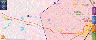
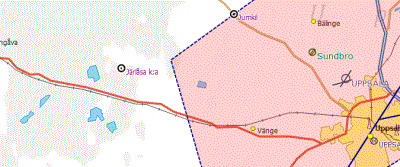
You can see the improved accuracy in how the roads are rendered. But you can also see that all waterways are gone and so are the villages of Vittinge, Järlåsa and Lövstalöt. Well, actually, in the new charts you can see a fragment of the river in the upper right corner. (Yes, I have enabled rivers in the mapping settings! There are rivers shown in other places.)