|
giannisd
|
|
|
Group: Forum Members
Posts: 99,
Visits: 173
|
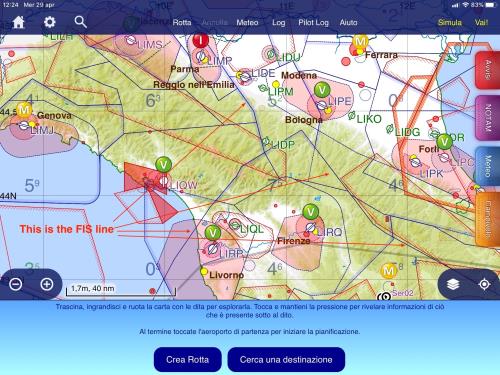
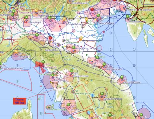
Hi, On the Italian PC map the FIS/FIC area is not depicted as the FIS/FIC tablet maps. The correct airspace is on the tablet, I know that is not easy because the FIR area does not correspond to the FIS/FIC, but would be possible to make the airspace identical on both maps ? regards, Gianni
|
|
|
|
|
Tim Dawson
|
|
|
Group: Forum Members
Posts: 8.2K,
Visits: 9.8K
|
There's no difference between the map rendering on PC and mobile. Could you post screenshots?
FIS boundaries are not normally rendered on any SkyDemon map, as they are inspectable via the What's Here menu or Radio screen (on mobile) or in the Pilot Log.
|
|
|
|
|
giannisd
|
|
|
Group: Forum Members
Posts: 99,
Visits: 173
|
+xThere's no difference between the map rendering on PC and mobile. Could you post screenshots?
FIS boundaries are not normally rendered on any SkyDemon map, as they are inspectable via the What's Here menu or Radio screen (on mobile) or in the Pilot Log.
added 2 files, iPAD and PC,. On the iPad you'll see both lines, blu line is FIS, grey line is FIR, on the PC you'll not see the FIS line, only grey Fir line, the problem is on all 3 Italian FIR. On national AIP you'll find all the coordinates. We have discuss this log time, you amend the iPad map but not the PC map. regards, Gianni
 
|
|
|
|
|
grahamb
|
|
|
Group: Forum Members
Posts: 628,
Visits: 30K
|
I don't believe they are FIS boundaries, but they are boundaries between different sectors of Class D controlled airspace, which happen to correspond with the FIS areas. They are appearing differently due to different levels of 'decluttering' filtering between the two devices.
|
|
|
|
|
giannisd
|
|
|
Group: Forum Members
Posts: 99,
Visits: 173
|
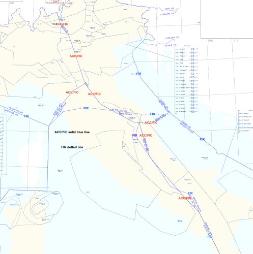
+xI don't believe they are FIS boundaries, but they are boundaries between different sectors of Class D controlled airspace, which happen to correspond with the FIS areas. They are appearing differently due to different levels of 'decluttering' filtering between the two devices. No Grahm, the Milano FIR is, divided in 2 area: Milano ACC/FIC and Padova ACC/FIC, the southern boundaries does not follow the boundaries between Milano and Rome FIR due to VHF transmission difficulties. Look at the official map, you will see a green line dividing the FIR boundaries between Milano and Rome starting from left, near Livorno/Pisa, then south of Florence and then to East near Pergola IFR point on the bottom right corner of the map. With solid blue you can see a line dividing the Milano ACC/FIC from Rome ACC/FIC, the line is starting from North of Pisa to South West of Bologna, where is written BOLOGNA CTR, then intersect the Padova ACC/FIC line, then go to bottom right corner of the map and is dividing Padova ACC/FIC to Rome ACC/FIC. Little complicated ? Yes but we must live on that. The center/south of Italy is again complicated, the ACC/FIC area between Rome and Brindisi does not follow the boundaries of the FIR due to VHF trasmission problems because of the mountains. The FIS in Milano FIR is class G have several freq (4) , depending where you are.... Above 2500 ft is CTA D class or TMA A class. 
|
|
|
|
|
grahamb
|
|
|
Group: Forum Members
Posts: 628,
Visits: 30K
|
+x+xI don't believe they are FIS boundaries, but they are boundaries between different sectors of Class D controlled airspace, which happen to correspond with the FIS areas. They are appearing differently due to different levels of 'decluttering' filtering between the two devices. No Grahm, the Milano FIR is, divided in 2 area: Milano ACC/FIC and Padova ACC/FIC, the southern boundaries does not follow the boundaries between Milano and Rome FIR due to VHF transmission difficulties. Look at the official map, you will see a green line dividing the FIR boundaries between Milano and Rome starting from left, near Livorno/Pisa, then south of Florence and then to East near Pergola IFR point on the bottom right corner of the map. With solid blue you can see a line dividing the Milano ACC/FIC from Rome ACC/FIC, the line is starting from North of Pisa to South West of Bologna, where is written BOLOGNA CTR, then intersect the Padova ACC/FIC line, then go to bottom right corner of the map and is dividing Padova ACC/FIC to Rome ACC/FIC. Little complicated ? Yes but we must live on that. The center/south of Italy is again complicated, the ACC/FIC area between Rome and Brindisi does not follow the boundaries of the FIR due to VHF trasmission problems because of the mountains. The FIS in Milano FIR is class G have several freq (4) , depending where you are.... Above 2500 ft is CTA D class or TMA A class.  That may be the case, but every one of the lines you annotate in your top image is a Class D boundary, which are visible when you set the decluttering filter to >12500' amsl. As you reduce that filter the boundaries progressively disappear.
Check that the 'decluttering' filters are set to the same values on both your tablet and PC, and you will see the same Class D boundaries.
|
|
|
|
|
giannisd
|
|
|
Group: Forum Members
Posts: 99,
Visits: 173
|
+x+x+xI don't believe they are FIS boundaries, but they are boundaries between different sectors of Class D controlled airspace, which happen to correspond with the FIS areas. They are appearing differently due to different levels of 'decluttering' filtering between the two devices. No Grahm, the Milano FIR is, divided in 2 area: Milano ACC/FIC and Padova ACC/FIC, the southern boundaries does not follow the boundaries between Milano and Rome FIR due to VHF transmission difficulties. Look at the official map, you will see a green line dividing the FIR boundaries between Milano and Rome starting from left, near Livorno/Pisa, then south of Florence and then to East near Pergola IFR point on the bottom right corner of the map. With solid blue you can see a line dividing the Milano ACC/FIC from Rome ACC/FIC, the line is starting from North of Pisa to South West of Bologna, where is written BOLOGNA CTR, then intersect the Padova ACC/FIC line, then go to bottom right corner of the map and is dividing Padova ACC/FIC to Rome ACC/FIC. Little complicated ? Yes but we must live on that. The center/south of Italy is again complicated, the ACC/FIC area between Rome and Brindisi does not follow the boundaries of the FIR due to VHF trasmission problems because of the mountains. The FIS in Milano FIR is class G have several freq (4) , depending where you are.... Above 2500 ft is CTA D class or TMA A class.  That may be the case, but every one of the lines you annotate in your top image is a Class D boundary, which are visible when you set the decluttering filter to >12500' amsl. As you reduce that filter the boundaries progressively disappear.
Check that the 'decluttering' filters are set to the same values on both your tablet and PC, and you will see the same Class D boundaries. I realise that, but even lower than 10500 (is the limit to see it) we have to use and change freq. depending position, altitude, accordingly. In VFR is necessary to know the FIC/FIS boundary at any altitude and if I set 10500 ft on decluttering options, the screen become to cluttered with area that I can't (A class) or I do not intend to use. Maybe the solution is to increase more options in the Airspace menu like "Show CTA", "Show TMA". For instance, in Italy we have CTA D and A class and all TMA are A only. The decluttering options is difficult to set it up, the choice depend more on Class than altitude.
Thanks for your answer and instructions, Regards, Gianni
|
|
|
|
|
Tim Dawson
|
|
|
Group: Forum Members
Posts: 8.2K,
Visits: 9.8K
|
FIS boundaries are not shown in SkyDemon maps because the data is available elsewhere. The things you labelled on your screenshot are not FIS boundaries, as someone else has said.
|
|
|
|
|
giannisd
|
|
|
Group: Forum Members
Posts: 99,
Visits: 173
|
+xFIS boundaries are not shown in SkyDemon maps because the data is available elsewhere. The things you labelled on your screenshot are not FIS boundaries, as someone else has said.  Tim, good morning, Enlarge the screen and you will see that ACC/FIC (FIS) boundaries are not the same as the FIR. FIR is a dotted line, ACC/FIC (FIS) is a plain line, sometime they overlap each other. CTA are of different color line. regards, Gianni
|
|
|
|
|
Tim Dawson
|
|
|
Group: Forum Members
Posts: 8.2K,
Visits: 9.8K
|
Yes, we are well-aware of that information.
|
|
|
|