|
Florian Meissner
|
|
|
Group: Forum Members
Posts: 17,
Visits: 16
|
Hi SD Team,
I just updated my charts to the latest AIRAC (effective since yesterday) and noticed, that all sector boundaries for German FIS disappeared from the map. Does it have to do with the restructuring of FIS and that all sectors are now called Langen Information?
I remember from to AIRAC cycles ago, SD displayed the major FIR boundaries between Langen, Bremen and former Munich. I also remeber seeing the sector boundaries between Bremen North (Lower Saxony north of Bremen and Schleswig-Holstein), Bremen South (rest of lower Saxony) and Bremen East (Brandenburg and Mecklenburg-Vorpommern).
Now, with the new AIRAC the FIRs have merged into Langen FIR (Munich has merged one or two years ago) but SD still shows the old FIR boundaries but does not show the individual sectors and frequencies anymore.
I already spoke to other SD users of our club and they reported the same across PC, Android and iOS.
Is it because DFS is slow to release new data? Or is there anything I can do to help you? I just recently got the new papaer charts from DFS beeing effective since yesterday and they show the new sectors. If you like, I can scan these charts for you or create some custom data files and mail them to you.
Florian
|
|
|
|
|
Max
|
|
|
Group: Forum Members
Posts: 3,
Visits: 0
|
I also noticed some errors in the new AIRAC data of Skydemon. FIR boundaries are gone, but FIS frequencies in the north of Germany are still called "Bremen information" instead of the new uniform "Langen information".
Another thing I found are the temporary (HX) C airspaces southwest of EDDK (Köln/Bonn) are still there in SD, but are removed in the new ICAO chart.
I hope this will get cleaned up soon.
|
|
|
|
|
Tim Dawson
|
|
|
Group: Forum Members
Posts: 8.3K,
Visits: 9.9K
|
SkyDemon has never shown FIS sector boundaries.
The FIRs in Germany have not changed. Perhaps there is a terminology misunderstanding here?
We have contacted DFS in case the FIS sectors have changed but that this was not properly communicated in the AIRAC amendments disseminated in the normal fashion.
|
|
|
|
|
Florian Meissner
|
|
|
Group: Forum Members
Posts: 17,
Visits: 16
|
Until recently SD shown a line on the map (I think green dashed) and provided a label in the virtual radar like "Bremen Information 119.825" with is definitely FIS! Also this information disappeared from the frequency section of the PLOG.
I could count up at least 5 SD customers from our club who asked me about this and would like to have this feature back. Unlike you seem to do it in the UK, FIS does provide radar based traffic and airspace information to VFR pilots. Thus, knowing the exact frequencies and assigned areas is vital for us.
So no matter how you call this feature, bring it back, please!
If you did not get any data with the latest AIRAC this could be because of a delay in publishing them from DFS. The change of all sectors became effective MAR 28 the same date the new 2019 VFR paper charts became effective. No NOTAM or other "official" information has been released to us pilots before. We only received a good-bye letter from the Bremen FIS controllers since their positions where moved to Langen.
If I can do anything to help you getting the necessary data, let me know!
Florian
|
|
|
|
|
Tim Dawson
|
|
|
Group: Forum Members
Posts: 8.3K,
Visits: 9.9K
|
SkyDemon has never shown lines delineating FIS sectors on our maps. Dotted green or otherwise.
DFS have sent us some new data this morning. After some inspection hopefully it'll be the new FIS data. We will incorporate this data today and issue a new chart update, if so, but you won't get those green lines. However, frequencies will be shown in the PLOG and in virtual radar as they always have been.
|
|
|
|
|
emporer
|
|
|
Group: Forum Members
Posts: 69,
Visits: 5
|
Hi Tim,in the virtual radar i also don’t see the FIS FREQUENCIES any more! Neither on my iphon6 nor on my Samsung Tabs 2, even when zooming in.
and it was definitly shown a while ago.
On German ICAO maps the FIR boundaries are shown (green dashed lines) and I always missed them in SD. I also see no real reason why you don’t show them as an additional layer to be toggelable in the layer menu option.
|
|
|
|
|
Tim Dawson
|
|
|
Group: Forum Members
Posts: 8.3K,
Visits: 9.9K
|
You may not see FIS frequencies in virtual radar on phones, where the screen isn't wide enough to display this information comfortably.
In all cases, all you have to do is long-press anywhere on the map to see the FIS frequency at that point. When you inspect that, the outline of its area will show briefly too.
|
|
|
|
|
Johannes Köhn
|
|
|
Group: Forum Members
Posts: 21,
Visits: 44
|
Hi Tim,
The name of FIS in the north of germany is now displayed correctly - thank you!
But the airspaces C that are active at the weekend are still displayed in the area of cologne. But these airspaces no longer exist since 28th of march.
Looking forward to see you on the AERO in Friedrichshafen Best regards Johannes
|
|
|
|
|
Tim Dawson
|
|
|
Group: Forum Members
Posts: 8.3K,
Visits: 9.9K
|
Could you point me to these airspaces? I've just spent ten minutes checking what we have against AIP Germany ENR 2.1 and everything seems to be correct.
|
|
|
|
|
Johannes Köhn
|
|
|
Group: Forum Members
Posts: 21,
Visits: 44
|
+xCould you point me to these airspaces? I've just spent ten minutes checking what we have against AIP Germany ENR 2.1 and everything seems to be correct. 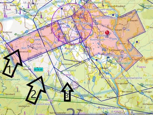 No 1: Airspace C FL 65 to FL 100 No 2: Airspace C FL 65 to FL 100 No 2: Airspace C 4.500 to FL 100
Best regards Johannes
|
|
|
|