|
BerndHS
|
|
|
Group: Forum Members
Posts: 29,
Visits: 198
|
This is really great news! I'm keen to see this feature working!
|
|
|
|
|
spoek
|
|
|
Group: Forum Members
Posts: 3,
Visits: 1
|
Hi Tim,
any news about the German georeferenced Aerodrome Charts? Or are they already available in the current SD version and I am doing something wrong so that I do not find them? ;-)
As said in the previously post, I would really appreciate that feature, as well... :-D
Best regards,
Marco
|
|
|
|
|
Tim Dawson
|
|
|
Group: Forum Members
Posts: 8.3K,
Visits: 10K
|
No, there is currently no update on this, sorry. I will ask Eisenschmidt again.
|
|
|
|
|
Tim Dawson
|
|
|
Group: Forum Members
Posts: 8.3K,
Visits: 10K
|
They're not able to easily pass on the data we require, but have suggested a (time-consuming) workaround.
Could you give me 5-10 German airfields that are popular and you think would benefit from having georeferenced diagrams? I will try and georeference them and we can all look at the results.
|
|
|
|
|
tschnell
|
|
|
Group: Forum Members
Posts: 25,
Visits: 149
|
In my opinion georeferenced aerodrome charts would be especially helpful on towered aerodromes - in most cases you do not really even need the airport diagram on small, uncontrolled fields. OTOH, the really big airports are not the most popular VFR destinations, so perhaps the medium-sized airports with considerable GA traffic would be a start.
My ranking is derived from the number of PIREPs posted for the airfields on a popular community website in Germany (eddh.de). These are the "Top Ten" airports:
EDDC - Dresden (66)
EDXW - Sylt (64)
EDDE - Erfurt (62)
EDNY - Friedrichshafen (62)
EDDV - Hannover (60)
EDDH - Hamburg (58)
EDDN - Nuernberg (50)
EDDS - Stuttgart (45)
EDAH - Heringsdorf (44)
EDVK - Kassel (44)
Tobias
|
|
|
|
|
Tim Dawson
|
|
|
Group: Forum Members
Posts: 8.3K,
Visits: 10K
|
I've done all those for you, except Dresden. We can't do that as it's too rotated, unfortunately. Still, we will await some real-world feedback from the others.
|
|
|
|
|
thobie
|
|
|
Group: Forum Members
Posts: 2,
Visits: 16
|
Hi Tim,
thanks a lot for preparing the charts. Is there any chance that you get the information from DFS that you need for georeferencing all charts? If not, what do you think about crowdsourcing the "(time-consuming) workaround" you mentioned in one of your earlier posts? I think that many SkyDemon users would be willing to help to improve SkyDemon and its data. Furthermore, this would be an approach that could be used for other charts, like IFR plates, too, which are not in your main focus. This would make SkyDemon very attractive for a broader user group.
Thanks,
Thorsten
|
|
|
|
|
Tim Dawson
|
|
|
Group: Forum Members
Posts: 8.3K,
Visits: 10K
|
Hi, we would never crowd source such critical information because of the risk of error involved. We need to control all such data ourselves. Over the years we've had the opportunity to see crowd sourced aeronautical data of various types, and it has always contained glaring (to us) errors, unfortunately.
There does not appear to be a massive demand for the German aerodrome charts to be georeferenced. As you'll see further up this thread I did do a few and asked for feedback. That was months ago, and I did not receive a single reply.
|
|
|
|
|
thobie
|
|
|
Group: Forum Members
Posts: 2,
Visits: 16
|
OK, thanks for the clarification. I understand your concerns of publishing user-generated georeferencing information. Nevertheless, is there any chance to let us know how it works, e.g., by providing information on the format or access to the required tools, such that users can do it for just themselves?
|
|
|
|
|
tschnell
|
|
|
Group: Forum Members
Posts: 25,
Visits: 149
|
Tim, sorry for not giving a timely feedback to the charts I "requested" - but better late than never: Somehow I was hoping that the "georeferenced" charts would be zoomable Airport Diagrams integrated into the basemap, just like Friedrichshafen was shown as a teaser fo future developments on the last AERO show. The new airport diagrams do not seem to blend into the basemaps as nicely as e.g. the approach charts. This is, for example, what I get in Nuremberg EDDN in simulation mode. I have not had a chance to try it out on an actual flight to one of the airports, though. Tobias 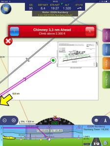
|
|
|
|