|
Tim Dawson
|
|
|
Group: Forum Members
Posts: 8.2K,
Visits: 9.7K
|
The way we technically implement map overlays means we are not going to be putting map features on top of the rainfall any time soon, sorry.
Rainfall data is not real-time and should absolutely not be used in flight for any tactical purpose. We are thinking very strongly about making it completely unavailable during flight for this reason.
There isn't currently anything in the UI to tell when the forecast you're looking at was issued, simply because we're running out of space to display such things. We don't want to turn a supposedly simple feature into information overload. Suggestions welcome!
|
|
|
|
|
neilmurg
|
|
|
Group: Forum Members
Posts: 42,
Visits: 128
|
Nexus 7, android 6.01 Worked fine, rain disappears when you Zoom in, that's OK. I wondered if it would be better to show the 2/3 last rain pictures to give an idea of track. I wouldn't want to use it while flying. Personally happy to use raintoday for this as part of my weather planning, but useful as a final check without opening another window. Does it store the rain picture so it can display last one received when offline? [Edit] yes it does, and displays what time received [/edit] [Edit2]oh slider, thanks!, missed that[Edit2] [Edit3]Slider is great!, and it does a bit of the future  . I take it back, this is WAY better than raintoday. The weather tab does take a lot of real estate when animating tho' (sshot). The ability to run the animation was terrific, I wonder if it could be set to run 3/5 times and to close the weather tab while it does it (would need a time display)[/Edit3] 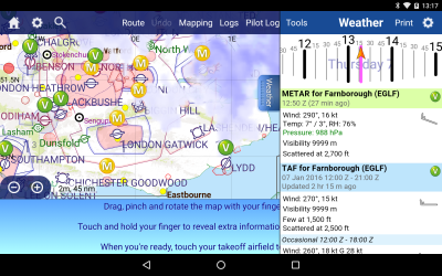 Samsung galaxy s4 cyanogenmod 4.4.4, rooted Didn't work, displayed pink overlay: fair enough  screenshot available
|
|
|
|
|
Tim Dawson
|
|
|
Group: Forum Members
Posts: 8.2K,
Visits: 9.7K
|
Zooming "through the clouds" to look at the map underneath is part of the rainfall features. I don't understand what you mean referencing "the 2/3 last rain pictures"; the slider gives you the ability to scroll back through time, forward through time or to animate the rainfall over time.
I've just uploaded a new beta, with a few issues sorted and a potential alternative means of discovery of the feature. There's a new Settings dropdown under the Weather tab which is where you can turn on and off all mapped weather features, and in the weather window itself it only shows the status, to save space. More feedback welcomed!
|
|
|
|
|
rikur
|
|
|
Group: Forum Members
Posts: 132,
Visits: 632
|
Tim Dawson (1/7/2016)
Rainfall data is not real-time and should absolutely not be used in flight for any tactical purpose. We are thinking very strongly about making it completely unavailable during flight for this reason.Mixed views on this. Initial reaction is to agree - if it's likely to be out of date, it's potentially misleading and a 'false friend' .... then I think about the real-world, and when have I dipped into the met-office app to look at rainfall radar .... e.g. last month I was over the lake district trying to get back to the east coast ... I was visually aware of a line of CBs/rain showers over the Pennines and trying to assess how far south I would be likely to need to go to get clear of them, and whether this would still give me room to route North of Leeds CTA or whether I'd need to route further around the West and South of it (and hence whether I set a course of South, or South Easterly). In that context I'm not making a short term weather avoidance manoeuvre in the way an airliner would use weather radar - but I'm using it to aid a tactical routing decision, and will ultimately be looking out of the window to decide on final flightpath. However, given the human factors likelihood of someone treating them like a real-time weather radar, and given they mask the terrain shading - probably safest in balance to suppress them in flight. Tim Dawson (1/7/2016)
There isn't currently anything in the UI to tell when the forecast you're looking at was issued, simply because we're running out of space to display such things. We don't want to turn a supposedly simple feature into information overload. Suggestions welcome!I'm guessing in practice the transition from 'actual' to 'forecast' gives a reasonable indication as to when they were last updated. Do they auto expire if too old? My concern on this is from a planning rather than in-flight perspective, that you may find yourself looking at a 12 hour old forecast assuming it is much more up to date?
|
|
|
|
|
rikur
|
|
|
Group: Forum Members
Posts: 132,
Visits: 632
|
neilmurg (1/7/2016)
Didn't work, displayed pink overlay: fair enough screenshot available I've also intermittently had the pink overlay issue - closing SD and reopening it seemed to clear it for me.
|
|
|
|
|
Mike@EDTG
|
|
|
Group: Forum Members
Posts: 164,
Visits: 757
|
Tim
logout bug has been sorted out.
thx
-mike
|
|
|
|
|
Tim Dawson
|
|
|
Group: Forum Members
Posts: 8.2K,
Visits: 9.7K
|
The pink overlay appears for tiles that haven't been downloaded. That isn't a bug; tiles are only downloaded near your route, or where you've done a Get Weather for an airfield. You can also do a Get Weather for Chart if you want to see an entire country's rainfall. Our rainfall coverage is so wide that we don't want to download it all automatically; that would cause bandwidth and memory problems on some devices.
We only have rainfall forecasts available one hour into the future. Therefore it would never be possible to be looking at a rainfall forecast more than an hour old. One of the things I changed in today's beta, though, was to change the text so you CAN see when the forecast was issued. So we're looking for feedback on that as well as the other minor UI changes I mentioned above.
|
|
|
|
|
rikur
|
|
|
Group: Forum Members
Posts: 132,
Visits: 632
|
Hi Tim
Feedback on latest version....
When I first fire up the app and open the weather tab the date/time slider appears to be defaulting to 1015 on Saturday 26th not now.
Your explanation about the pink makes sense, seems to be when i've selected a time outside the data validity.
I cannot find anymore the text stating whether it is a forecast or actual, nor the new text showing update time that you reference.
|
|
|
|
|
Tim Dawson
|
|
|
Group: Forum Members
Posts: 8.2K,
Visits: 9.7K
|
The text is now only displayed if there is room. Perhaps you're using SkyDemon on a phone?
The slider definitely does not default to that date; are you loading a route with that date set as your takeoff time?
|
|
|
|
|
Pete
|
|
|
Group: Forum Members
Posts: 129,
Visits: 959
|
Think I prefer previous mode of rain selection, its now more convoluted.
Re rain display in flight, think it should remain an option possibly with appropriate warning. Users should be well aware of its limitations, we are grown ups.....well most of us:-)
|
|
|
|