|
Isaache
|
|
|
Group: Forum Members
Posts: 10,
Visits: 27
|
Hi, For what I can see France Digital Terrain Model resolution is good enough to be viewed at 1:100.000 scale and be close to 1 sample per pixel on the other hand Spain DTM roughly is 20 times less dense, there is an official source (Instituto Geografico Nacional / National Geographic Institute) available at 200, 25 and 5 meters per pixel for the whole Spanish territory. Is there any chance you could use that source (it is free for personal use but I believe it is paid for commercial use) to improve the actual SD? http://www.ign.es/ign/layoutIn/modeloDigitalTerreno.doThanks Isaac
|
|
|
|
|
Tim Dawson
|
|
|
Group: Forum Members
Posts: 8.3K,
Visits: 9.9K
|
No; we tend not to use local terrain models. We use global terrain models and use either STRM30 or STRM3 data depending on the area in question. For general aviation use the 30-arc-second data is fine to help people stay out of trouble and to shade the background of the charts. In mountainous terrain (currently just the Alps and the Pyrenees) we upgrade to the 3-arc-second data just in those specific regions as the extra resolution is helpful.
If there is a specific area which you believe could benefit from an upgrade we would take a look at it. But since we're not even using the highest resolution global data available to us, it's unlikely we would use an even higher resolution terrain model.
|
|
|
|
|
Isaache
|
|
|
Group: Forum Members
Posts: 10,
Visits: 27
|
Hi Tim,
Excellent approach, I personally would prefer to see the highest density possible SRTM all around (after all it is free) but I understand the benefits of your approach (lower bandwidth cost, faster refresh rate on lower end machines,...), I will have to spend some time thinking if there is more areas where higher density may be beneficial but my first impression is that I will not be able to argue with your approach.
Thanks
Isaac
|
|
|
|
|
Isaache
|
|
|
Group: Forum Members
Posts: 10,
Visits: 27
|
Hi Tim, Spain is the second roughest country in Europe after Switzerland, you will not see big heights but the terrain constantly goes up and down, this is a (mostly) irrelevant fact for General Aviation but it is a critical factor for gliders and Ultra Light aircraft (in Spain the law mandates that Ultra Lights must fly below 1000 feet AGL). I don't consider myself qualified to decide what should and what should not be represented at a higher DTM density (you already clarified what is your policy on this) so I will provide some elements to decide what should be done. 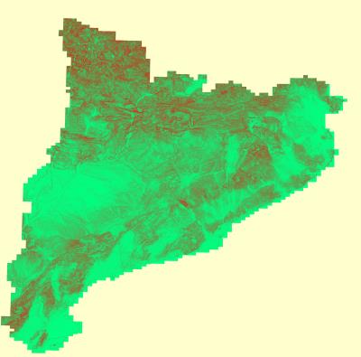 This map covers Catalunya (North East of Spain), the red color indicates a slope of 60% or higher and the green color represents a 0% slope, as you can see most of the country displays high terrain height variability which may be a factor for low flying (<1000 feet). This example can be extended to most of the Spanish ground with some exceptions, if you want I can present a similar study for the rest of the Country (at high resolution not like the image presented here). Cheers Isaac
|
|
|
|
|
Tim Dawson
|
|
|
Group: Forum Members
Posts: 8.3K,
Visits: 9.9K
|
I often wonder how the authorities expect ultralights to know their exact height above the ground so they can ensure it's less than 1000ft.
|
|
|
|
|
Sky Painter
|
|
|
Group: Forum Members
Posts: 627,
Visits: 15K
|
They obviously expect ultra lights to be equipped with radar altimeters! Ha Ha!
Mike _________________________________________ Samsung Galaxy Tab A8 – Android 11.0 & SD 4.2.3 Huawei P30 – Android 11.0 & SD 4.2.3
PC – Windows 11 (Home Ed) Version 25H2, Build 26200.7840, SD 4.2.3
|
|
|
|
|
Isaache
|
|
|
Group: Forum Members
Posts: 10,
Visits: 27
|
Hi Sky Panter, Some days ago I was pretty close to go "smarty pants" and say something on the lines of " oh well, they want everyone with SkyDemon in a SRTM3 elevation model" luckily I didn't open my mouth that fast as apparently there are RA specifically designed for UAVs and ULMs http://www.wavenetradio.com/pdf/Cat-RA-01-GA-en.pdfI have seen this thing at about 1600 Euro which I would say it is a reasonable price. Isaac
|
|
|
|
|
Sky Painter
|
|
|
Group: Forum Members
Posts: 627,
Visits: 15K
|
Hi Issac Well, whadya know! I won't be so quick to open my mouth next time 
Actually, it looks like a nice bit of kit.
Mike _________________________________________ Samsung Galaxy Tab A8 – Android 11.0 & SD 4.2.3 Huawei P30 – Android 11.0 & SD 4.2.3
PC – Windows 11 (Home Ed) Version 25H2, Build 26200.7840, SD 4.2.3
|
|
|
|
|
Tim Dawson
|
|
|
Group: Forum Members
Posts: 8.3K,
Visits: 9.9K
|
I would think it was reasonable to interpret that rule as "you must fly less than 1000 feet below the highest terrain within a kilometre laterally" which SkyDemon's own Height reading would give you. Is that not the case?
|
|
|
|
|
guille
|
|
|
Group: Forum Members
Posts: 149,
Visits: 2.4K
|
I agree completely with Tim. Last year I made a flight of several days in Spain and discussing with Spanish pilots, they confirmed that the rule can have a relatively "soft" interpretation. An error of 200 or even 300 ft can be acceptable. The height values given by SD are, in my opinion, enough, no need of a perfect accuracy. Of course this is not official information.
|
|
|
|