|
ckurz7000
|
|
|
Group: Forum Members
Posts: 538,
Visits: 2.2K
|
Hi Tim, here are my thoughts.
First, I would think that there ought to be two PLOGs, a planning version when on the ground and a flying version when actually navigating.
The user ought to be able to customize which columns are displayed in each, simply because needs differ. The flying version ought to be "live" in the sense that all values are updated dynamically as the flight progresses.
In my personal flying version I would opt for the following columns:
Waypoint ID: ID or full name as per selection in the chart settings
leg length: that would actually be distance to next waypoint and updated live. For passed points: planned distance.
ground speed: easy, updated live. For passed points: average ground speed.
ETA: live and based on actual off block time. For passed points: ATA
cumulative fuel used: (based on aircraft profile climb/descent profile and elapsed time)
cumulative distance flown: live
cumulative time flown: live
comm frequency: suggested by SD but user editable.
All heading/course/wind correction stuff I get from following the magenta line on the map. The altitude, climb and descent I get from the vertical profile.
Greetings, -- Chris.
|
|
|
|
|
Tim Dawson
|
|
|
Group: Forum Members
Posts: 8.3K,
Visits: 9.9K
|
I'm pretty uncomfortable with the notion of attempting to change every column to be a "live" version of itself. I don't really see the benefit, it seems like an attempt to make everything "live" without good reason. I have to say, the thought of guessing at fuel amounts in a "live" way makes me pretty uncomfortable too.
I much prefer the idea of hiding some of the less-useful "planning" columns while in flight, preserving others, and adding new columns which do have real meaning when flying, such as ETA and ATA.
|
|
|
|
|
Sky Painter
|
|
|
Group: Forum Members
Posts: 627,
Visits: 15K
|
I'm totally in agreement with this point of view.
Mike _________________________________________ Samsung Galaxy Tab A8 – Android 11.0 & SD 4.2.3 Huawei P30 – Android 11.0 & SD 4.2.3
PC – Windows 11 (Home Ed) Version 25H2, Build 26200.7840, SD 4.2.3
|
|
|
|
|
ckurz7000
|
|
|
Group: Forum Members
Posts: 538,
Visits: 2.2K
|
I see this differently. A glance at the PLOG should tell me exactly where in the flight I am and what's still ahead of me. having columns updated live will give me exactly that. Agreed I have so far lived without that feature and will be able to do so in the future but it is simply taking all abilities of a portable computer and using it in a meaningful and easily comprehensible way. Let me turn the question around: what's the downside of having the current leg being updated live?
Just to clarify: it would only be the data of the current leg that's updated live, of course. All previous legs would have actual values and all future ones planned values. So the flight PLAN is progressively turning into a flight LOG, with the present leg showing actual, live updated values. Isn't that a coherent and useful metaphor? Just like in real life?
Regarding fuel used: SD would do exactly what a pilot is supposed to do, i.e., estimate fuel burn based on performance data of the aircraft and time elapsed. Or is there anyone still alive who trusts fuel gauges? So why not assisst the pilot in this task? Is it potential liability issues holding you back?
-- Chris.
|
|
|
|
|
Tim Dawson
|
|
|
Group: Forum Members
Posts: 8.3K,
Visits: 9.9K
|
Certainly liability is a big concern. We're a very popular product and our exposure is high. The trouble with fuel estimation (and we had a lengthy discussion in the office about this yesterday) is that we don't actually know how you're flying the plane. We know what your plans were, but people often don't stick to the plan. You might be flying with a much higher power setting, you might have done more climbing, you might have been flying into much more of a headwind than was forecast. At the end of the day, you might have a lot less fuel than we say you have. I'd much rather not say anything. I don't think we'll be moving from that stance regarding fuel estimation. The trouble with having "real" values for the current leg is that we're then showing differently-sourced values for one leg than we are for the other boxes under the same column. I do like the metaphor of a plan turning into a log, but I'm not sure how obvious that metaphor would be to everybody else. Some columns do not particularly lend themselves to this either. It's like we'd be trying to replace the boxes of the current leg in the PLOG by duplicating our actual instruments which of course are available elsewhere. We posted on Facebook soliciting feedback for this very topic this week, and if nothing else, it shows just how varied the opinions are regarding the PLOG. It's obviously a very personal thing, and certainly a feature where we can't please everybody. https://www.facebook.com/SkyDemonVFR
|
|
|
|
|
ckurz7000
|
|
|
Group: Forum Members
Posts: 538,
Visits: 2.2K
|
Tim Dawson (10/17/2014)
Certainly liability is a big concern. We're a very popular product and our exposure is high. The trouble with fuel estimation (and we had a lengthy discussion in the office about this yesterday) is that we don't actually know how you're flying the plane. We know what your plans were, but people often don't stick to the plan. You might be flying with a much higher power setting, you might have done more climbing, you might have been flying into much more of a headwind than was forecast. At the end of the day, you might have a lot less fuel than we say you have. I'd much rather not say anything. I don't think we'll be moving from that stance regarding fuel estimation.OK, I can sort of understand where you're coming from even though I don't share your opinion entirely.
The trouble with having "real" values for the current leg is that we're then showing differently-sourced values for one leg than we are for the other boxes under the same column. I do like the metaphor of a plan turning into a log, but I'm not sure how obvious that metaphor would be to everybody else. Some columns do not particularly lend themselves to this either. It's like we'd be trying to replace the boxes of the current leg in the PLOG by duplicating our actual instruments which of course are available elsewhere.
I see no problem with "differently-sourced" values in the PLOG. Let's just step back and put ourselves into the shoes of the pilot. You look at the PLOG and now, in one glance, have a full overview of what's been, what is, and what's planned to be. That's exactly what I would like to see. Yes, some of the instrument values from the map page will show up in the PLOG as well. So what? They are important values and you see them in a different context on the PLOG. There it shows you the history, present and future of these values. Is the headwind stronger than planned? If so, I can see that effect directly from the PLOG because future ETAs will be updated according to the flight's progress. I can print the PLOG after the flight, if so desired, and have a good record of what happened. Printing it before the flight gives me a record of what was planned. -- Chris.
|
|
|
|
|
Tim Dawson
|
|
|
Group: Forum Members
Posts: 8.3K,
Visits: 9.9K
|
Again, I like the metaphor, but I don't think we've heard that request from anyone else. We'll start slowly and make the ETA/ATA columns the first to change to be "live" in the live plog (and give them a different background colour to match). Once that's live we could look at which other columns could be made "live" on the current leg and whether it'll be obvious what they are then indicating.
We were having a discussion today about whether it would be worth getting rid of the Radio screen and simply incorporating it into the Live PLOG. After all, the frequencies section of the "plan" PLOG will have disappeared, so it might be a natural place to put it. What do you think?
|
|
|
|
|
ckurz7000
|
|
|
Group: Forum Members
Posts: 538,
Visits: 2.2K
|
Tim Dawson (10/22/2014)
Again, I like the metaphor, but I don't think we've heard that request from anyone else. We'll start slowly and make the ETA/ATA columns the first to change to be "live" in the live plog (and give them a different background colour to match). Once that's live we could look at which other columns could be made "live" on the current leg and whether it'll be obvious what they are then indicating.That sounds like a good plan, Tim. I was just wondering if it wouldn't be confusing to have the entire column in a separate color. Why not only the cells that can still change, i.e., the ones in the future? That would focus the pilot's attention on exactly the area that have changing values based on the progress of the flight.
We were having a discussion today about whether it would be worth getting rid of the Radio screen and simply incorporating it into the Live PLOG. After all, the frequencies section of the "plan" PLOG will have disappeared, so it might be a natural place to put it. What do you think?
I think that would be a good idea. I believe that the PLOG offers the most potential for future development and might very well turn out to look quite different from the static sheet it is now. Here is my take on the frequency section: Every frequency (nav or comm) belongs to a particular leg, which is the leg on which you actually want to have this frequency tuned in on your radio. Therefore I wonder if it wouldn't be better to have a nav and comm frequency column, respectively rather than a separate section somewhere else on the PLOG. Everything pertaining to a particular leg would then be in the very line representing this leg. I am aware that screen area is limited and with it the number of columns that can be displayed comfortably. You'd have to come up with a way of hiding and showing columns or making specific information available if you do a long tap on a leg. On the other hand, the spreadsheet might well extend past the right display border and you simply pan right (such as when you pan the map around) to see the rest. I hope you find this discussion useful, -- Chris.
|
|
|
|
|
Tim Dawson
|
|
|
Group: Forum Members
Posts: 8.3K,
Visits: 9.9K
|
I disagree that frequencies could be incorporated in this way. Long legs may require the use of many different frequencies while flying them, for example, and on the other hand one frequency may be used for many smaller local legs. I don't want to attempt to integrate them with the lines of the waypoints section for this reason. We are very tempted to move the Radio screen into the PLOG but have not yet done so. We've made significant progress in the last few days; the PLOG (live and planned) has been standardised across iOS/Android and every section has been reviewed to ensure it fits properly on the target paper size (when printing) and the target screen size. This means the number of columns in which frequencies and navaids are displayed is dynamic. When flying, the columns that are "live" are highlighted in blue and the active leg is too, with a progress bar drawn to indicate how far through the leg you've travelled. Where waypoints are shown in the first column, these can be clicked on to reveal the same menu you'd get on the map, with options such as further information and Route Direct (making it easy to go directly to a future waypoint in your route). This is still a work in progress but I will post a screenshot of the PLOG that is currently shown when navigating (Android device). 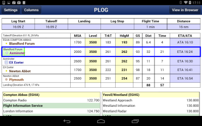
|
|
|
|