By Tim Dawson - 5/7/2020 11:26:31 AM
If you require additional, non-aviation-specific weather information, may I suggest you use a weather app. There are many out there, some cheap or free, that are very sophisticated and offer detailed weather analysis.
SkyDemon shows aviation-specific weather (METAR, TAF, GAFOR) and winds aloft out to around 2 days ahead. This is plenty for most pilots' needs when you consider the wealth of dedicated weather apps out there to supplement for longer-term planning. We do not currently plan to integrate more weather information for further ahead in time, as we have not observed a big demand for it.
There is no need to post screenshots of other apps or even mention them. We do not implement features just because other apps have them. By all means ask for a feature you would find useful - that's how we judge the features our target market want most - but we are very comfortable with our place in the market.
|
By hairy_kiwi - 5/8/2020 11:05:57 AM
+xAt the moment it is only possible to plan 5-6 hours in advance with us in Austria. Greetings Alex
Tim, I understand SD's position regarding product enhancement, however, if:
"SkyDemon shows aviation-specific weather (METAR, TAF, GAFOR) and winds aloft out to around 2 days ahead.", the question to my mind is:
Why or what is preventing Alex and his Austrian pals accesing this data such that they believe they are only able to plan 5-6 hours in advance?
Perhaps a misunderstanding of some aspect of the user interface?
Sincerely, Hamish
|
By Tom1969 - 5/17/2020 10:01:28 PM
The weatherforecast from MFD was very good and I also miss this feature. I know that fey have worked with an Italian weather provider. The forecast of MFD was very sharp for days and also more detailed like Gafor.
+2 ( Also for a friend he hast also Changed to SD from MFD) 😉
|
By hairy_kiwi - 5/19/2020 1:22:37 PM
Correct me if I'm wrong @screen – I finally saw the feature requested in your first post:
My understanding is the request is for multi-day GFS forecasted cloud base and visibility data to be added to the GFS wind and precipitation data already available in SD; 24 hrs ahead for wind and unspecified for rainfall data – according to the latest user manual.
I agree: It would be great to be able to pick up just one app, SD, and with a quick zip back and forth of a slider UI, see both a plan (and ideally cross-section) view of multi-day forecast weather along my desired route.
Currently, if the weather might be at all murky for the days I have available to go VFR flying, I need to enter my route in a meteogram site/app such as autorouter.aero's gramet (pretty pdf output, easy UI) or Ogimet.com's gramet (almost as nice, but a poor UI) and play with the flight time to derive the best day – and time of day for my flight. Or in yet another weather site/app in which a time of day slider is provided, such as weatheronline.co.uk ~ Cloudbase (GFS) or wxcharts.com ~ Overview (ICON-EU) - and thereafter imagine my route relative to the terrain and weather.
So +1 to include in SD, a graphical plan (and ideally cross-section) view of GFS sourced visibility and cloud-base for the x days in advance the GFS system can facilitate, or some reasonable compromise, say 2 - 5 days if its otherwise a significant load on the SD servers. |
By screen - 5/29/2020 9:22:57 AM
+xCorrect me if I'm wrong @screen – I finally saw the feature requested in your first post:
My understanding is the request is for multi-day GFS forecasted cloud base and visibility data to be added to the GFS wind and precipitation data already available in SD; 24 hrs ahead for wind and unspecified for rainfall data – according to the latest user manual.
I agree: It would be great to be able to pick up just one app, SD, and with a quick zip back and forth of a slider UI, see both a plan (and ideally cross-section) view of multi-day forecast weather along my desired route.
Currently, if the weather might be at all murky for the days I have available to go VFR flying, I need to enter my route in a meteogram site/app such as autorouter.aero's gramet (pretty pdf output, easy UI) or Ogimet.com's gramet (almost as nice, but a poor UI) and play with the flight time to derive the best day – and time of day for my flight. Or in yet another weather site/app in which a time of day slider is provided, such as weatheronline.co.uk ~ Cloudbase (GFS) or wxcharts.com ~ Overview (ICON-EU) - and thereafter imagine my route relative to the terrain and weather.
So +1 to include in SD, a graphical plan (and ideally cross-section) view of GFS sourced visibility and cloud-base for the x days in advance the GFS system can facilitate, or some reasonable compromise, say 2 - 5 days if its otherwise a significant load on the SD servers. Yes, exactly, it would be an enormous relief! |
By marioair - 5/29/2020 10:16:47 AM
+x+xCorrect me if I'm wrong @screen – I finally saw the feature requested in your first post:
My understanding is the request is for multi-day GFS forecasted cloud base and visibility data to be added to the GFS wind and precipitation data already available in SD; 24 hrs ahead for wind and unspecified for rainfall data – according to the latest user manual.
I agree: It would be great to be able to pick up just one app, SD, and with a quick zip back and forth of a slider UI, see both a plan (and ideally cross-section) view of multi-day forecast weather along my desired route.
Currently, if the weather might be at all murky for the days I have available to go VFR flying, I need to enter my route in a meteogram site/app such as autorouter.aero's gramet (pretty pdf output, easy UI) or Ogimet.com's gramet (almost as nice, but a poor UI) and play with the flight time to derive the best day – and time of day for my flight. Or in yet another weather site/app in which a time of day slider is provided, such as weatheronline.co.uk ~ Cloudbase (GFS) or wxcharts.com ~ Overview (ICON-EU) - and thereafter imagine my route relative to the terrain and weather.
So +1 to include in SD, a graphical plan (and ideally cross-section) view of GFS sourced visibility and cloud-base for the x days in advance the GFS system can facilitate, or some reasonable compromise, say 2 - 5 days if its otherwise a significant load on the SD servers. Yes, exactly, it would be an enormous relief! I'd like this too |
By marioair - 5/29/2020 10:28:49 AM
+x+x+xCorrect me if I'm wrong @screen – I finally saw the feature requested in your first post:
My understanding is the request is for multi-day GFS forecasted cloud base and visibility data to be added to the GFS wind and precipitation data already available in SD; 24 hrs ahead for wind and unspecified for rainfall data – according to the latest user manual.
I agree: It would be great to be able to pick up just one app, SD, and with a quick zip back and forth of a slider UI, see both a plan (and ideally cross-section) view of multi-day forecast weather along my desired route.
Currently, if the weather might be at all murky for the days I have available to go VFR flying, I need to enter my route in a meteogram site/app such as autorouter.aero's gramet (pretty pdf output, easy UI) or Ogimet.com's gramet (almost as nice, but a poor UI) and play with the flight time to derive the best day – and time of day for my flight. Or in yet another weather site/app in which a time of day slider is provided, such as weatheronline.co.uk ~ Cloudbase (GFS) or wxcharts.com ~ Overview (ICON-EU) - and thereafter imagine my route relative to the terrain and weather.
So +1 to include in SD, a graphical plan (and ideally cross-section) view of GFS sourced visibility and cloud-base for the x days in advance the GFS system can facilitate, or some reasonable compromise, say 2 - 5 days if its otherwise a significant load on the SD servers. Yes, exactly, it would be an enormous relief! I'd like this too if anyone's interested I'm trying to drum up support for Tim to make changes to allow concurrent traffic and weather feeds in to SD. show your support here: |
By screen - 5/11/2020 5:42:57 AM
+xIf you require additional, non-aviation-specific weather information, may I suggest you use a weather app. There are many out there, some cheap or free, that are very sophisticated and offer detailed weather analysis.
SkyDemon shows aviation-specific weather (METAR, TAF, GAFOR) and winds aloft out to around 2 days ahead. This is plenty for most pilots' needs when you consider the wealth of dedicated weather apps out there to supplement for longer-term planning. We do not currently plan to integrate more weather information for further ahead in time, as we have not observed a big demand for it.
There is no need to post screenshots of other apps or even mention them. We do not implement features just because other apps have them. By all means ask for a feature you would find useful - that's how we judge the features our target market want most - but we are very comfortable with our place in the market. 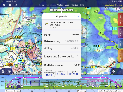 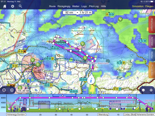 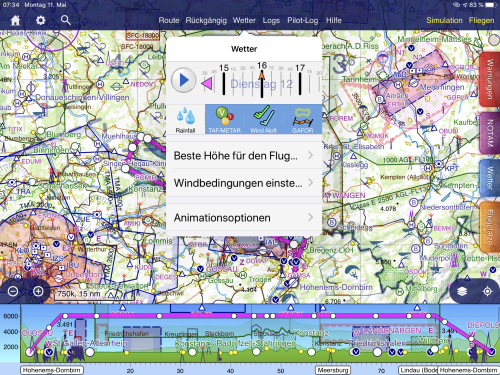 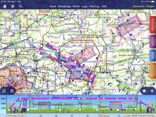
Hello Tim,
thank you for your answer. Since we mainly fly in the Alps, the weather is very, very important for us !!
Of course there are a lot of other apps for the weather, I think the goal should be to have an app with as much information as possible. The good weather apps cost money again. :-)
Here is an example of flight planning. In the first two pictures you can see the weather for a current (now) departure. 11 May 05:19 UTC
In the next two pictures (pic 3+4), the weather for the planned flight on May 12, 16:00 UTC is visible. Unfortunately, I don't see any more weather data here. Is it because of the settings?
LG Alex
|
By Tim Dawson - 5/11/2020 9:00:54 AM
It isn't clear what sort of weather data you're actually talking about. The only thing I can see on the top two pictures that isn't in the bottom two is rainfall radar/forecast, which is only really accurate out to a few hours ahead so we don't include anything further than that.
TAF and METAR of course only go as far as they are issued.
|
By pilot-byom - 5/11/2020 9:57:26 AM
+xIt isn't clear what sort of weather data you're actually talking about. The only thing I can see on the top two pictures that isn't in the bottom two is rainfall radar/forecast, which is only really accurate out to a few hours ahead so we don't include anything further than that.
TAF and METAR of course only go as far as they are issued.
Just a short remark. The German DWD does publish graphical and grid data including rain forecast radar as trend for up to 7 days in the future. Nevertheless by no obvious or reasonable reason this is not included in their AviationWeather.app, where only the last 24h are shown. The sister app 'WarnWetter" does show the radar forecast for a week in advance. Maybe worth a talk to them whether Skydemon can incorporate that data? |
By screen - 5/11/2020 10:33:27 AM
+xIt isn't clear what sort of weather data you're actually talking about. The only thing I can see on the top two pictures that isn't in the bottom two is rainfall radar/forecast, which is only really accurate out to a few hours ahead so we don't include anything further than that.
TAF and METAR of course only go as far as they are issued.
In the first two pictures you can see the weather for a current (now) departure. 11 May 05:19 UTC In the next two pictures (pic 3+4), the weather for the planned flight on May 12, 16:00 UTC is visible.
In the second picture I can no longer see weather data (wind, gafor, taf, etc. ...)
|
By screen - 5/11/2020 10:45:21 AM
+x+xIt isn't clear what sort of weather data you're actually talking about. The only thing I can see on the top two pictures that isn't in the bottom two is rainfall radar/forecast, which is only really accurate out to a few hours ahead so we don't include anything further than that.
TAF and METAR of course only go as far as they are issued.
Just a short remark. The German DWD does publish graphical and grid data including rain forecast radar as trend for up to 7 days in the future. Nevertheless by no obvious or reasonable reason this is not included in their AviationWeather.app, where only the last 24h are shown. The sister app 'WarnWetter" does show the radar forecast for a week in advance. Maybe worth a talk to them whether Skydemon can incorporate that data? Alternatively, there is also "RunwayMap" because there is the whole weather for 7 days in advance. Price about 14 euros a year
|
By pilot-byom - 5/11/2020 11:41:45 AM
+x+x+xIt isn't clear what sort of weather data you're actually talking about. The only thing I can see on the top two pictures that isn't in the bottom two is rainfall radar/forecast, which is only really accurate out to a few hours ahead so we don't include anything further than that.
TAF and METAR of course only go as far as they are issued.
Just a short remark. The German DWD does publish graphical and grid data including rain forecast radar as trend for up to 7 days in the future. Nevertheless by no obvious or reasonable reason this is not included in their AviationWeather.app, where only the last 24h are shown. The sister app 'WarnWetter" does show the radar forecast for a week in advance. Maybe worth a talk to them whether Skydemon can incorporate that data? Alternatively, there is also "RunwayMap" because there is the whole weather for 7 days in advance. Price about 14 euros a year
You don't need a paid 'App' for the data, all results of underlying weather models are free on the net and i.e. GFS data goes as far as 384h or 16 days into the future - with limited confidence though. |
By Tim Dawson - 5/11/2020 2:28:43 PM
You'll never see GAFOR, METAR and most TAF that far out: the data simply does not exist. That isn't how GAFOR, METAR and TAF work. Exceptionally, a TAF will have a longer life, and SkyDemon will include that. This is basic aeronautical weather information and I assume you know that.
Other weather things like wind, temperature, visibility are available through models like GFS for many days in advance but we currently only include wind, as there simply hasn't been much demand for the other stuff and there are plenty of decent weather-specialised apps out there.
|
By pilot-byom - 5/11/2020 6:37:22 PM
+xYou'll never see GAFOR, METAR and most TAF that far out: the data simply does not exist. That isn't how GAFOR, METAR and TAF work. Exceptionally, a TAF will have a longer life, and SkyDemon will include that. This is basic aeronautical weather information and I assume you know that.
Other weather things like wind, temperature, visibility are available through models like GFS for many days in advance but we currently only include wind, as there simply hasn't been much demand for the other stuff and there are plenty of decent weather-specialised apps out there. I totally agree. Extrapolation and interpretation of far future weather data requires special skills for judgement. Who is able to do that, don't need it in Skydemon but uses the original data, the others - shouldn't use it.
|
By screen - 5/7/2020 5:08:39 AM
Good Morning,I have now discussed the weather forecast in SD with several flight colleagues.We came to the conclusion that flight planning with the SD weather tool is very difficult. At the moment it is only possible to plan 5-6 hours in advance with us in Austria.
With the former Jeppeesen program (moible fligth deck) it was possible to check the weather (visibility, base of the clouds, wind, etc.) for about 3 days in advance. (Sorry Tim that I mention MFD again)
The whole thing was possible with a slide controller. See attachementwhat do you think of this possibility?
Greetings Alex
|
|